https://topographical-surveys.com Secures Landmark UK Contract Using Leica RTC360 Scanner for 3D Printing in Film
Under the contract, Topographical‑Surveys.com’s expert team will deploy the Leica RTC360, capable of capturing up to 2 million points per second
Next‑Gen 3D Reality Capture in London
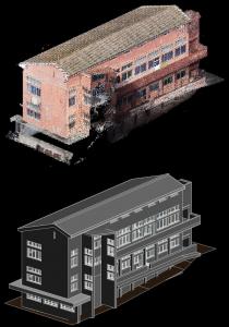
Under the contract, Topographical‑Surveys.com’s expert team will deploy the Leica RTC360, capable of capturing up to 2 million points per second, with under‑two‑minute HDR scans—delivering high‑fidelity data ideal for photorealistic 3D prints and cinematic digital models https://topographical-surveys.com/land-surveyors-london
The first phase will capture structures such as the Tower of London, St Paul’s Cathedral, and the London Eye, laying the groundwork for film studios seeking exact replicas for physical sets and digital environments. https://topographical-surveys.com/land-surveyors-london
Topographical Surveying: Foundation of Modern Design
A topographical survey—also known as a land survey, site survey, or contour survey—maps natural and built features across a site, including elevations, contours, utilities, vegetation, and structures. In the UK, these surveys underpin everything from urban development in London and Manchester to rural planning, infrastructure design, and environmental projects https://topographical-surveys.com/
By gathering centimetre‑accurate data with GPS, total stations, LiDAR, and laser scanning, surveyors deliver essential information for architects, engineers, local authorities, and heritage planners. Topographical‑Surveys.com leverages these techniques nationwide—from Greater London to Greater Manchester, and across all major UK cities. https://topographical-surveys.com/
Why Topographical Surveys Matter in the UK
Planning & Compliance – Essential for UK planning applications, aligning designs with terrain and local authority regulations.
https://topographical-surveys.com/land-surveyors-brighton
Risk Management – Identifies hazards such as uneven ground, flood risk, and subsidence early—preventing future cost overruns.
Design Precision – Enables architects and engineers to create site‑specific structures that respond to topography and existing infrastructure.
Heritage Recording – Captures historical buildings accurately, preserving them digitally—a critical element in heritage‑sensitive contexts.
In bustling city environments like London and Manchester, high-density development demands precise site information to coordinate utilities, address airspace constraints, and support multi-storey construction. Similarly, rural and environmental planners rely on survey data to model flood plains, greenbelt boundaries, and agricultural land management.
Leica RTC360: Power, Precision & Pace
Topographical‑Surveys.com chose the Leica RTC360 for its unrivalled performance:
Compact & Robust – Lightweight and backpack-portable at ~5 kg with collapsible tripod—ideal for navigating city streets ﹣ essential for film‑set workflows
High Accuracy – Sub‑3 mm precision at 10 m ensures detailed fidelity, essential for 3D printing and CGI model building
These features allow Topographical‑Surveys.com to scan landmarks quickly and accurately, providing film studios with ready‑to‑print 3D data and immersive digital twins.
Landmark Scanning for Film
Each landmark produces point clouds that feed into post‑processing workflows to generate mesh models suitable for 3D printing, physical scale models, or virtual sets. This service supports:
Set Fabrication – Accurate printed facades and props https://topographical-surveys.com/land-surveyors-london
Visual Effects – Real‑world geometry for CGI scenes
Virtual Filming – Digitally reconstructed environments for virtual production
Topographical‑Surveys.com is a UK‑based firm specialising in 3D laser scanning, topographical and measured building surveys, UAV photogrammetry, and GIS data capture. Certified by RICS and utilising Ordnance Survey‑aligned methods, the company guarantees precision and compliance.
Topographical Surveying in the UK – Accurate Mapping for Land Development
Topographical surveying in the UK is essential for developers, architects, planners, and engineers who require precise data about land features before starting a project. A topographical survey (also known as a land or topo survey) provides a detailed and accurate representation of the natural and man-made features of a specific site — including ground levels, buildings, roads, trees, boundaries, and utility lines.
At Topographical-Surveys.com, we use state-of-the-art surveying technology including Leica total stations, GPS systems, UAV drones, and 3D laser scanners to deliver fast, reliable, and cost-effective topographic surveys throughout London, Manchester, Birmingham, Glasgow, and across the UK.
Whether you’re planning a housing development, infrastructure upgrade, or commercial construction project, a topographical survey reduces risk by identifying elevation changes, drainage issues, and hidden site constraints early in the planning process.
We produce detailed CAD drawings and digital terrain models (DTMs) to support architectural design, civil engineering, and planning applications. Our experienced team works closely with local councils and developers to ensure compliance with UK building regulations and planning laws.
If you’re looking for professional topographical surveying in the UK, trust our specialists for high-accuracy data, fast turnaround times, and excellent customer support.
For more information or to arrange a scan:
Next-gen GNSS delivers real-time positioning with centimeter accuracy
Heartbeat imaging offers new insight into oyster freshness
Douglas Eze of Largo Financial Services on a Mission to Boost Financial Literacy Nationwide
Kalendarium
Więcej ważnych informacji
 Jedynka Newserii

 Jedynka Newserii

Prawo

KE proponuje nowy Fundusz Konkurencyjności. Ma pobudzić inwestycje w strategiczne dla Europy technologie
W środę 16 lipca Komisja Europejska przedstawiła projekt budżetu na lata 2028–2034. Jedna z propozycji zakłada utworzenie Europejskiego Funduszu Konkurencyjności o wartości ponad 400 mld euro, który ma pobudzić inwestycje w technologie strategiczne dla jednolitego rynku. Wśród wspieranych obszarów znalazła się obronność i przestrzeń kosmiczna. Na ten cel ma trafić ponad 130 mld euro, pięciokrotnie więcej niż do tej pory.
Firma
Były prezes PGE: OZE potrzebuje wsparcia magazynów energii. To temat traktowany po macoszemu

Choć udział odnawialnych źródeł energii w miksie energetycznym Polski jest stosunkowo wysoki i rośnie, to ten przyrost jest chaotyczny i nierównomiernie rozłożony miedzy technologiami – wskazuje Forum Energii. Dodatkowo OZE potrzebują wsparcia magazynów energii, a zdaniem Wojciecha Dąbrowskiego, prezesa Fundacji SET, ten temat jest traktowany po macoszemu. Brak magazynów powoduje, że produkcja energii z OZE jest tymczasowo wyłączana, co oznacza marnowanie potencjału tych źródeł.
Infrastruktura
Wzrost wynagrodzeń ekip budowlanych najmocniej wpływa na koszty budowy domu. Zainteresowanie inwestorów mimo to nieznacznie wzrasta

Budowa metra kwadratowego domu w Polsce kosztuje od 5,55 do 6 tys. zł w zależności od województwa – wynika z najnowszych analiz firmy Sekocenbud. Najdrożej jest w Warszawie, gdzie cena za metr kwadratowy domu przekroczyła już 6,2 tys. zł. Na przyrosty kosztów budowy domu wpływają zarówno drożejące materiały budowlane, jak i wyższe wynagrodzenia pracowników. Inwestorzy nie rezygnują jednak z budowy domów jednorodzinnych, co ma związek m.in. z wciąż wysokimi cenami mieszkań czy też obniżką stóp procentowych.
Partner serwisu
Szkolenia

Akademia Newserii
Akademia Newserii to projekt, w ramach którego najlepsi polscy dziennikarze biznesowi, giełdowi oraz lifestylowi, a także szkoleniowcy z wieloletnim doświadczeniem dzielą się swoją wiedzą nt. pracy z mediami.


.gif)

 |
| |
| |
|